
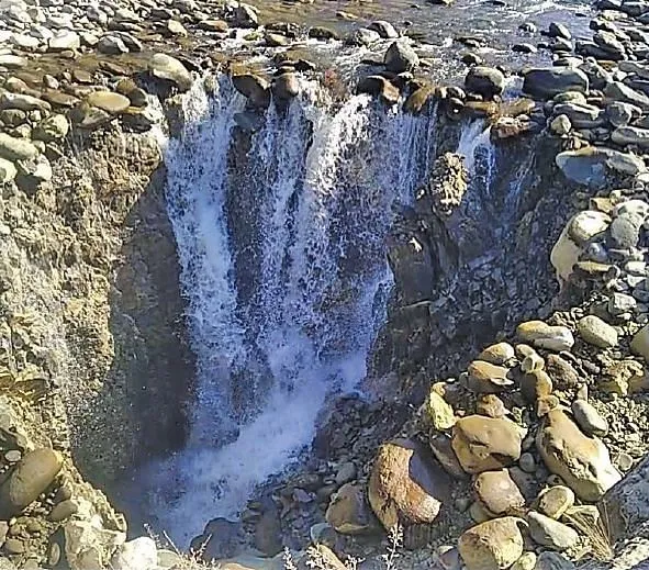


Anantnag: The tracer studies by a team of National Institute of Technology (NIT) Srinagar has confirmed the sinkhole that emerged in the middle of Brengi at Wandevalgam in Kokernag on February 11 this year has its discharge 16 kilometres downstream at Achabal.
Deputy Commissioner Anantnag, Dr Piyush Singla took to Twitter saying there could be many other outlets in nearby areas. “ Kokernag Sinkhole at Wandevalgam- Tracer studies by NIT Srinagar observed – Sinkhole has an outlet at Achabal. There could be other outlets in the nearby area.
Interesting interference from the interesting phenomenon,” the DC Tweeted. The 7 feet deep vertical hole had gulped the entire water leaving several kilometers of the downstream portion dry and killing the precious trout fish in large numbers.
It had also raised concerns among the framers relying on the water of this Brengi stream, a major tributary of Jehlum for irrigating their agricultural land.
The efforts to divert the water had failed to yield any results with similar cavities surfacing nearby. The authorities finally decided to fill up the sinkhole and the water started flowing smoothly again in the middle of March. Experts from the department of Earth sciences at the University of Kashmir and the Geology and Mining department had also visited the spot and suggested measures.
The district administration finally roped in a team of experts from NIT to find the underground water flow of the sinkhole. “The team did an exhaustive tracer study and submitted its final report to us. Interesting things have come to the fore regarding the springs and underground water channels due to the Karst topography of the area, ”DC said. The team also found five relatively smaller sinkholes both upstream and downstream.
“The water diverted from the major sinkhole was observed to seep through these small sinkholes, lying nearly in a linear pattern. The linear alignment of the sinkholes suggests a possible underground connection in a major cavern,” the report observed. It also found that a significant discharge was observed in the Achabal springs during the period when most of the discharge was diverted to a sinkhole. “The increase in discharge levels at Achabal was consistent with the timing of diverting the discharge into the sinkhole and tracer concentration detected,” the report mentioned.
It said, “The increase was observed after 5 hours of diverting the flow into the sinkhole. Once the flow into the sinkhole was stopped, a decrease in discharge was observed. This clearly signifies a well connected underground cavity system”.
The study, according to the report, indicates that the sinkhole is facilitated by dynamic cavern zones with a significant variation of hydraulic properties, geometry, trend, and dimension. Interestingly, in the second week of March, the springs of the famous Achabal Botanical garden had suddenly swelled causing panic among the locals.
The water level later slowly came down. Locals had witnessed a similar phenomenon some twenty-seven years back in the year 1995 when one such sinkhole developed in the stream a few meters above in the same area. It was also later filled up with sand and gravel and the water of the channel had later found its discharge at Achabal Sinkholes are a natural phenomenon formed due to the gradual chemical dissolution of limestone rocks in the river.
However, experts besides tracer studies have been suggesting a geophysical and gravity survey to ascertain the path of the cavities- the underground river system and to prevent any disaster.
Meanwhile, the National Disaster Management Authority today held a detailed meeting on the Kokernag Sinkhole event. The meeting held through virtual mode, was attended by representatives from NDMA, Central Water Commission, Geological Survey of India, National Centre for Earth Sciences, Central Water and Power Research Stations, National Institute of Hydrology, Wadia Institute of Himalayan Geology, Indian Institute of Remote Sensing, Relief Commissioner, J&K SDMA and District Administration Anantnag, Irrigation and Flood Control.
At the beginning, SDM Kokernag through a presentation put forth the background of the event. He said that the district administration has filled the sinkhole with naturally graded material and crates.
He said that a multi departmental team including representatives from Kashmir University, NIT Srinagar, Geology Department, Fisheries, Jal Shakti and Revenue department conducted a detailed study.
Based on the preliminary study and tracer studies conducted through NIT Srinagar, it was inferred that the phenomenon occurred due to underlying karst topography. He further said that 90 percent of the water going into the sinkhole has an outlet in Achabal which is 16 kms from the sinkhole. The report of the committee was shared with the participants.
While the team has taken immediate preventive steps, a thorough discussion on the future course of action was held.
All the participants in the meeting agreed that the response so far has been scientifically based and has been instrumental in preserving the site for future studies.
NDMA desired that proposal for centrally funded studies be sent to ensure that detailed geomorphology of the underlying karst topography can be understood and future interventions designed accordingly.
It is in place to mention that after the occurrence of the event, District Administration under the vigil of Deputy Commissioner Anantnag had taken immediate steps to prevent any tragedy at the spot including issuing of detailed news briefs to quell rumour mongering, imposing Section 144 to prevent any mishap and creating diversionary canals to safeguard the interests of agriculturists.
Preliminary studies including Proton Precession Magnetometer studies were conducted and the decision to fill the sinkhole was taken after due deliberation with all stakeholders.